Applications are not currently being accepted for the certificate program. You may fill out the contact sheet below to be informed of future application cycles.
*U.S. Department of Labor, Bureau of Labor Statistics, Occupational Outlook Handbook - Cartographers and Photogrammetrists
With a focus on science and technology, the online Certificate of Advanced Study in Geographic Information Systems (GIS) provides important skills in a growing STEM field. An already large $10 billion market in GIS technology is projected to increase to nearly $20 billion within the next five years.
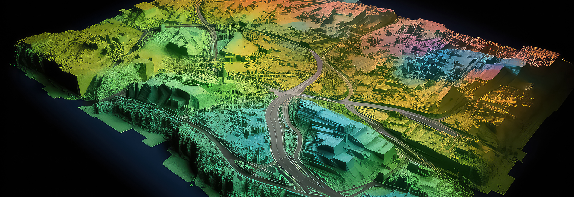
GIS is the process of using digital technology to aid in the evaluation of spatial information. GIS professionals acquire, manage, analyze, visualize, and represent geospatial data.
GIS Certificate students will learn the principles and real-world applications of geographic information systems while building highly marketable job skills. Upon graduation, students will be able to:
The GIS Certificate is comprised of 12-units of graduate-level coursework. Students take two classes per semester.
1st 8-weeks
EES 211. Fundamentals of GIS
Fundamental concepts and techniques of GIS; hands-on labs on data exploration and analysis; advanced skills in spatial and 3-D analysis on terrain and watershed delineation; midterm and final term projects. (3 units)
2nd 8-weeks
EES 212. Geospatial Technologies
The course introduces global positioning systems, remote sensing, and light detection and ranging technology and their integration with Geographic Information Systems. (3 units)
1st 8-weeks
EES 214. Advanced Spatial Analysis
Spatial analysis is an advanced course in GIS that exposes students to an array of spatial analysis theories, techniques, and practices. Reading, demonstrations, applied assignments. (3 units)
2nd 8-weeks
EES 216. GIS Practicum
Culminating experience for the GIS Certificate designed to demonstrate advanced working knowledge of GIS. Proposal; data privacy and management; GIS project; documentation; write-up; and presentation. (3 units)
Courses will be conducted online on Canvas, Fresno State's learning management system.
Admitted students will receive access to ArcGIS Pro at no charge. Visit the ArcGIS Pro website to learn more about the software and system requirements for your computer.
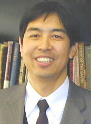
Dr. Zhi (Luke) Wang
Dr. Zhi (Luke) Wang is Professor of Hydrology and Soil Physics at California State University, Fresno in the Department of Earth and Environmental Sciences, and is the Coordinator of this GIS Certificate Program. Dr. Wang learned GIS in the 1990s and has been teaching the subject on campus since 2002. His PhD dissertation and many of his research involved many of the GIS applications, especially the 3-D, surface and geostatistical analyses. Dr. Wang participated in many ESRI user conferences, hands-on training sessions and user-model collaborations, and presented as a speaker in several of California’s local GIS meetings. His GIS analysis maps on the Fresno River Monitoring project were adopted by the Madera County Library for display to the public.Dr. Wang teaches courses in Hydrology, Hydrogeology, GIS, Geostatistics, Soil and Environmental Sciences. He has many publications in Water Resources Research, Journal of Hydrology, and other peer-reviewed journals.
Dr. Wang received his BS and MS degrees in civil engineering in China, his PhD degree in hydrology from the University of Leuven, Belgium, and his post-doctoral fellowship from the University of California, Riverside. His research on watershed hydrology and environmental hydrogeology has been funded by the US Natural Science Foundation, US Department of Defense, California EPA and California Department of Water Resources.
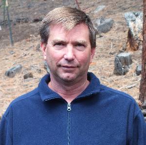
Dr. John McIntosh
Dr. John McIntosh has over 15 years experience with GIS and associated technologies. His research interests include GIS representation, remote sensing, environmental analysis and physical geography. John’s recent teaching experience has focused on geotechniques including classes in GIS, remote sensing and spatial analysis, statistics and programming. In addition to teaching, John’s experience includes work in the consulting and government sectors where he has been responsible for all aspects of GIS project implementation including project management, data development, analysis, statistics and programming.
John holds a Ph.D. in geography with an emphasis in geotechniques and physical geography, an MA in geography focusing on resource management and a BS in physical science.
Geographic information systems (GIS) collect data about the world around us. This relatively new discipline incorporates spatial analysis, remote sensing, geovisualization, geocomputation, cognition, and computer science. GIS professionals create maps that overlay locations with relevant supporting data concerning demographics, transportation, telecommunication, utilities, economics, public health, land use/resources, environmental conservation, and much more.
Geographic information systems require raw data, which is captured using cameras, digital scanners, lidar, or other means, or digitized from hardcopy maps or survey plans. The raw data is reformatted by a GIS to be useful in a variety of applications. Powerful analysis tools allow GIS professionals to identify patterns, trends, and relationships among the data. Businesses and governments use those analyses to make decisions that drive the economy and public policy.
GIS professionals often find work with federal agencies such as the U.S. Geological Survey, Bureau of Land Management, Army Corps of Engineers, Forest Service, National Oceanic and Atmospheric Administration, National Imagery and Mapping Agency, and Federal Emergency Management Agency. State and local agencies—including law enforcement, water and sewer agencies, tax assessors, planning and zoning departments, emergency bureaus, and homeland security—also require GIS professionals.
The vast majority of private sector jobs are with scientific (including medical fields), engineering, architectural, and technology firms. The private sector also employs GIS professionals in specialty mapping firms, surveying and land companies, oil, electric, and gas utilities, real estate agencies, banks and insurance companies, construction companies, and national businesses that regularly seek new franchise locations.
Nonprofit organizations such as environmental groups also need GIS professionals on a regular or consulting basis. Increasingly, private foundations use GIS as their main tool; examples include Conservation International which uses GIS as their method for identifying threatened habitats, and the Keoge Foundation which uses GIS extensively for climate modeling.